Greenlee County, Arizona
Arizona's least populous county, known for its stunning landscapes, rich copper mining history, and the spectacular Coronado Trail.
Greenlee County is located in eastern Arizona along the New Mexico border. As Arizona's least populous county, it offers a unique blend of industrial activity and natural wilderness. Established in 1909 as the last county formed in Arizona, it was carved out of Graham County and named after Mason Greenlee, an early settler who established mining claims in the area.
The county's landscape is defined by rugged mountains, deep canyons, and the Blue River, a tributary of the San Francisco River. The northern part of the county consists largely of the Apache-Sitgreaves National Forest, while the southern portion is dominated by copper mining operations, including the massive Morenci Mine, one of North America's largest copper mines. Despite its small population, Greenlee County has played a significant role in Arizona's mining industry and economic development. The combination of industrial mining heritage and pristine wilderness makes Greenlee County a compelling study in contrasts.
County Information
Demographics & Economy
Photos


Major Attractions
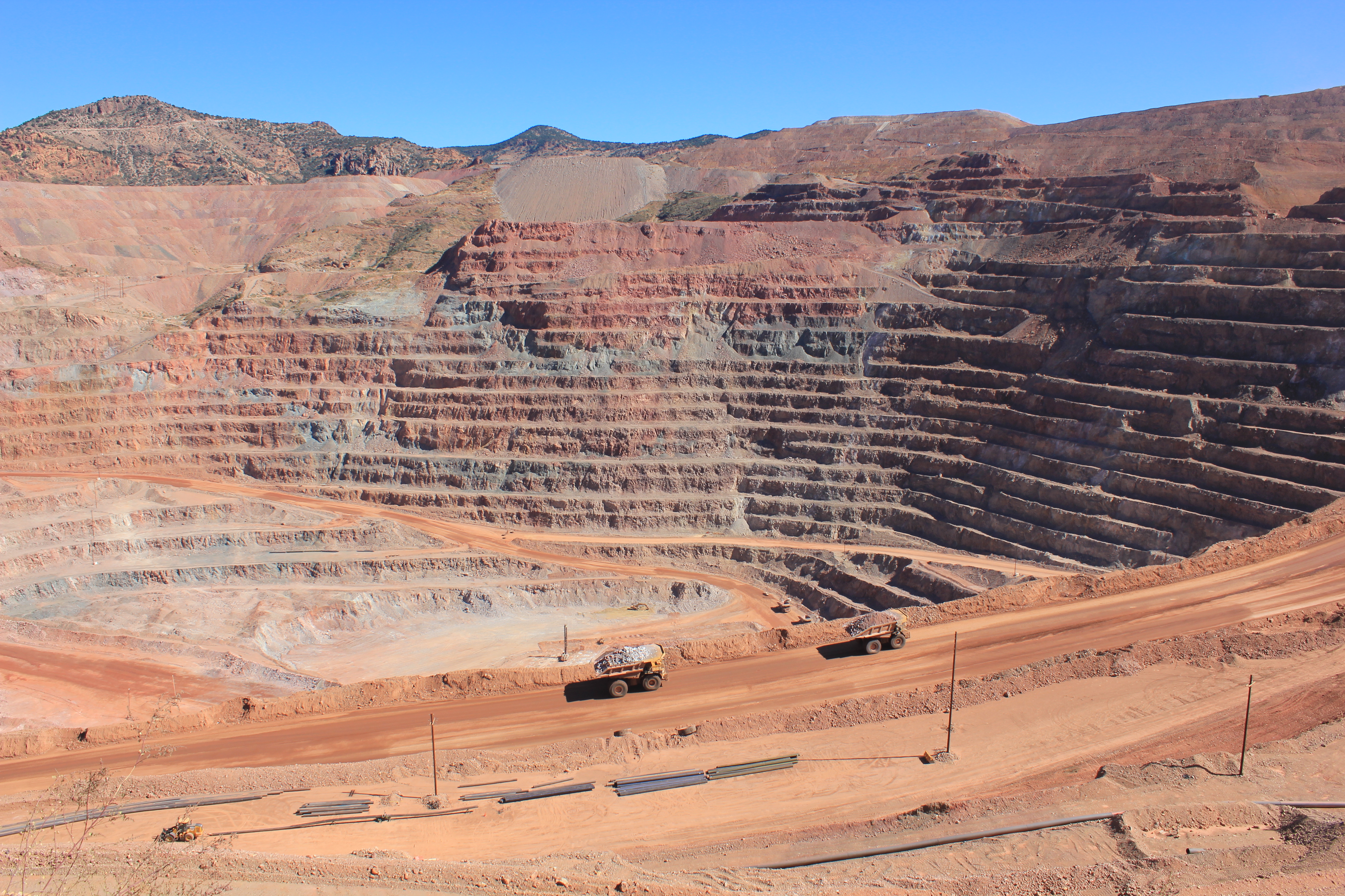
Morenci Mine
One of North America's largest copper mining operations, the Morenci Mine is an impressive open-pit complex that illustrates the scale of modern mining. While not a traditional tourist attraction, the mine is visible from several viewpoints, and its sheer size and industrial operations make it a point of interest. The mine produces over 900 million pounds of copper annually and employs thousands of workers.
Location: Near Morenci
Features: Massive open-pit copper mine, viewing opportunities from designated areas
Coronado Trail Scenic Byway (US-191)
Named after the Spanish explorer Francisco Vásquez de Coronado, this historic highway (formerly US-666 and sometimes called the "Devil's Highway") is regarded as one of America's most scenic and challenging drives. The winding road features over 460 curves as it climbs from the desert floor near Clifton to alpine forests at elevations over 9,000 feet. The 120-mile route offers spectacular views of diverse landscapes and ecosystems.
Location: Runs north-south through Greenlee County
Features: Dramatic elevation changes, switchbacks, scenic vistas, access to wilderness areas
Blue River
A pristine waterway that flows through a remote wilderness area in northern Greenlee County, the Blue River is cherished for its clear waters and unspoiled natural setting. The river and surrounding area offer opportunities for fishing, hiking, and wildlife viewing in a secluded environment. The Blue is a tributary of the San Francisco River and is known for its native fish populations.
Location: Northern Greenlee County
Features: Fishing for native trout, wildlife habitat, riparian ecosystem, primitive camping areas
Clifton Cliff Jail
This unusual historic site is carved directly into a cliff face overlooking the town of Clifton. Built in the late 1800s, the jail is a testament to Clifton's wild mining town past. The jail cells were chiseled into the solid rock of the cliffside, making escape nearly impossible. Today, visitors can see the carved-out chambers and imagine the harsh conditions that prisoners once endured.
Location: Clifton
Features: Historic jail cells carved into cliff, views of Clifton
Gila Box Riparian National Conservation Area
While primarily in neighboring Graham County, this conservation area extends into western Greenlee County. The 23,000-acre preserve protects important riparian corridors along the Gila and San Francisco Rivers, creating lush oases in an otherwise arid region. The area offers opportunities for rafting, wildlife watching, hiking, and camping in a spectacular canyon setting.
Location: Western boundary of Greenlee County
Features: River canyons, wildlife habitat, bird watching, historic sites, recreational opportunities
Frequently Asked Questions
Greenlee County is known for several distinctive features:
- Being Arizona's least populous county and one of the least populated counties in the United States
- The Morenci Mine, one of North America's largest copper mining operations
- The Coronado Trail Scenic Byway (US-191), considered one of America's most scenic and challenging drives
- Rich mining history dating back to the late 1800s
- Historic labor disputes and mining strikes that shaped Arizona's labor laws
- Pristine wilderness areas in the northern part of the county, including portions of the Blue Range Primitive Area
- The Blue River, known for its clear waters and native fish populations
- Being the last county formed in Arizona (1909)
- The historic towns of Clifton and Morenci with their mining heritage
Greenlee County is accessible via several transportation routes, though it is one of Arizona's more remote counties:
- By Car: The primary routes into Greenlee County include:
- US Highway 191 (Coronado Trail Scenic Byway) runs north-south through the county, connecting Clifton/Morenci to Alpine in the north and Interstate 10 near Safford in the south
- State Route 78 enters the county from New Mexico in the southeast
- US Highway 70 provides access to the southern part of the county from neighboring Graham County
- By Air: There are no commercial airports in Greenlee County. The nearest airports with commercial service are in Tucson (approximately 170 miles from Clifton) and Phoenix (approximately 200 miles from Clifton).
- By Bus: Limited bus service may be available to Clifton and Morenci.
Most visitors drive to Greenlee County, with the drive from Tucson to Clifton taking about 3 hours and Phoenix to Clifton taking approximately 4 hours. The remote nature of the county and the challenging roads (particularly the Coronado Trail) make advance planning important.
The best time to visit Greenlee County depends on which areas you plan to explore and what activities interest you:
- Spring (April-May): Generally pleasant temperatures throughout the county. The lower elevations around Clifton and Morenci experience warm days (70s-80s°F), while higher elevations along the Coronado Trail can still be cool. Spring brings wildflowers and good conditions for exploring most of the county.
- Summer (June-early July): The lower elevations can become very hot, often exceeding 100°F around Clifton. The higher elevations along the Coronado Trail offer relief with temperatures typically in the 70s-80s°F. Early summer is good for accessing the highest areas of the county.
- Monsoon Season (mid-July-September): Afternoon thunderstorms are common, bringing dramatic skies but potentially making outdoor activities and driving the Coronado Trail hazardous. Flash flooding can be a concern in canyons and along rivers.
- Fall (October-November): Many consider this the ideal time to visit, with cooling temperatures in the lower elevations and fall colors in the higher elevations. Weather is generally stable with less precipitation than summer.
- Winter (December-February): The lower elevations around Clifton and Morenci experience mild winters with daytime temperatures typically in the 50s-60s°F. The higher elevations along the Coronado Trail may receive significant snowfall, potentially closing sections of the road. Winter visitors should check road conditions before traveling on US-191.
Overall, late spring and fall offer the most pleasant weather for exploring all areas of Greenlee County. The Coronado Trail is typically most accessible from late spring through early fall, though conditions can vary.
Despite its small size, Greenlee County offers a variety of outdoor activities thanks to its diverse landscape:
- Scenic Driving:
- Coronado Trail Scenic Byway (US-191), one of America's most dramatic mountain highways
- Backcountry forest roads in the Apache-Sitgreaves National Forest
- Fishing:
- Blue River, known for its native Apache trout and other species
- San Francisco River, offering various fishing opportunities
- Eagle Creek, with secluded fishing spots
- Hiking & Backpacking:
- Trails throughout the Apache-Sitgreaves National Forest
- Blue Range Primitive Area
- Historic paths and mining trails near Clifton and Morenci
- Wildlife Viewing:
- Diverse wildlife including black bears, mountain lions, elk, deer, and numerous bird species
- Bird watching in riparian areas along the Blue and San Francisco Rivers
- Photography:
- Dramatic landscapes along the Coronado Trail
- Mining operations and historic mining structures
- Canyon vistas and wilderness settings
- Off-Highway Vehicle (OHV) Recreation:
- Designated OHV routes in the Apache-Sitgreaves National Forest
- Camping:
- Developed campgrounds in the northern part of the county
- Primitive camping in designated areas throughout the national forest
- Hunting:
- Seasonal hunting for various game species (permits required)
Visitors should check current regulations and conditions through the Apache-Sitgreaves National Forest or Greenlee County before planning activities, as some areas may have seasonal restrictions.
Major Communities
Clifton
County seat, population ~3,700, historic copper mining town
Morenci
Population ~1,500, company town for Morenci Mine
Duncan
Population ~700, agricultural community in southern Greenlee County
York
Small rural community along the Gila River
Blue
Tiny settlement in northern Greenlee County near the Blue River
Franklin
Small community in southern Greenlee County
Last reviewed on April 24, 2026.